15 Nov 2013

Niagara Falls, Canada-USA

Niagara Falls, Canada-USA


At the place where North American Niagara River separates two of the Great Lakes, Erie and Ontario, nature created a magnificent cascade of waterfalls. Each waterfall has its own name: the Horseshoe Falls, the American Falls, and the Bridal Veil Falls. However all of them are known under one name — Niagara Falls. This is the most important landmark of the USA and Canada at the same time, as it separates one country from another.
Niagara Falls
Great Lakes of North America, Niagara River, and its waterfalls are results of shifting of an ice shield that moved down from the Eastern Canada territory over ten thousand years ago. The glacier crashed everything on its way, deepening and widening riverbeds, and creating or eliminating lakes.
Interestingly enough, the geological characteristics of the area are such that the layers of soil are still moving, even if their movement is not as dramatic any more. During past centuries Niagara Falls have moved eleven kilometers south. According to scientists, the waterfall has been moving with the average speed of one, one and a half meters per year during last 560 years. Today special engineering efforts managed to slow the shifting a little bit.
Niagara Falls at winter
Photo: Evgueni Strok 
On the international scale Niagara Falls is not that high — just 53 meters. Here are few numbers for comparison: Angel Falls in Venezuela drops its water from 807 meters, and Victoria Falls in Zambia and Zimbabwe is 108 meters high. However the width of Niagara Falls is 792 meters. This fact places it together with the widest waterfalls in the world (comparing with Angel and Victoria — 107 and 1800 meters respectively).
These numbers demonstrate how different a waterfall can be. Every one of them is unique. It is also true for the waterfalls that form the Niagara Falls complex.
Niagara Falls
A small island called Luna separates the American Falls and the Bridal Veil Falls (that truly looks like a bridal wear). Their combined width is about 335 meters. At the same time, there is a giant pile of large sharp rocks at the foot of the American Falls, which makes a visible part of the waterfall 21 meter high.
Being separated by Goat Island, which was formed relatively late (the Niagara River was split into two channels about five hundred years ago), the Horseshoe Falls stands apart from the two. The speed and power of the American Falls are considerably less than those of the Horseshoe Falls, because Goat Island slows down masses of water; and in case of Horseshoe Falls, nothing stands on its way.
Niagara Falls
Named after deceased herd of artiodactyls, Goat Island is a popular tourist destination as it offers an opportunity to enjoy a spectacular view and also to take pictures of Niagara Falls. Little bridges connect the island with the US mainland and neighboring Luna Island. The Cavern of The Winds, another Niagara attraction, is also located here. From inside the cavern, one can admire the waterfall up close and also feel the power and presence of the big water. And when we say "power" we really mean it — drops of water shower you from head to toe! This is why each tourist receives a raincoat and waterproof footwear at the entrance to the cavern.
Niagara Falls
Niagara Falls attracts not only millions of tourists, but also those who want to experience extreme sensations. In 1829 Sam Patch became famous as a first man, who jumped from the Horseshoe Falls and survived. Another so-called record was set in 1901 by a 63-year-old Annie Taylor, who went over the waterfall in a barrel. The event of 1960 is rightfully called "The Miracle of Niagara", as a 7-year-old boy accidentally fell down the Horseshoe Falls and survived. Unfortunately, raging waters of Niagara Falls also took many human lives...
Niagara from the altitude of 500 meters
Location and position of Niagara Falls doesn't allow a group view of all the waterfalls from one spot. Some people believe that the most spectacular view opens from the Canadian shore; those who travel to Niagara Falls on American side are also satisfied with the picture. And now you have an opportunity to enjoy the magnificent panorama of all waterfalls from the widest possible angle — a bird's eye view — without a risk of getting wet or falling down the stream.

30 Oct 2013

Virtual Tour over Neuschwanstein Castle, Germany

Virtual Tour over Neuschwanstein Castle, Germany 


Germany is the land of fairy tales that gave the world Wilhelm Hauff and The Brothers Grimm, for example. Germany is also home to the most magical castle on the planet, Neuschwanstein Castle, the name of which translates as «The New Swan Cliff». It was built in the second half of the nineteenth century by Ludwig II of Bavaria, or as they called him, «The Fairy-Tale King».
Ludwig II holds a special place amongst other German rulers. What set him apart from his stringent and warrior-like predecessors was his romanticism and dreamy character, so much so that he channelled all of his statesman's passion (alongside with state funds) towards making his dreams come true, dreams of magical countries populated by fairy-tale creatures.
Disillusioned by the daily routines of Munich, Ludwig II was not interested in its problems. Instead, day by day he became more and more submerged in his own dream world. This gave the world several castles - Herrenchiemsee, Linderhof and Neuschwanstein, each one is a masterpiece of world architecture, enchanting us with its weightlessness and fairy-tale silhouettes with magnificent mountains as a backdrop.
Wartburg Castle was chosen as the model for Neuschwanstein as it is the only remaining castle from the feudal period in Bavaria. Ludwig the II's creation surpassed the original. At the time the King was very deeply moved by Richard Wagner's opera «Lohengrin», he saw himself in the opera's main character, the noble white swan-knight, a fairy-tale hero of the ancient legends. And with the help of architects he created his own «Swan Castle».
Fairy tale castle
The walls of the castle depict the magical world of «The Song of The Nibelungs» («Nibelungenlied»), medieval legends of Przival, Lohengrin and Tannhäuser, The Holy Grail, Tristan and Isolde... The masters spent a long time working very carefully on every hall and every panel painting, with every detail a true masterpiece. This is also the reason why the building work took so long and failed to reach completion even in Ludwig's lifetime. As an example, the wood carving in one bedroom took 14 carpenters 4 and a half years.
Yet the King had the incredible ability to combine fantasies with reality, and despite the castle's heavenly appearance, it was equipped with all the modern technology of its time. The rooms in the royal residence were fitted with hot air central heating, toilets were equipped with an automatic flushing system, electric bells were in place to summon servants and some floors even had telephones!
Neuschwanstein is first and foremost a true fairy tale made of stone. It became the prototype for the Sleeping Beauty castle in Disneyland Paris and a source of inspiration for Tchaikovsky's ballet «The Swan Lake». But in the end it drove the King insane, and instead of attending to the urgent duties of his country as a ruler, he went on expeditions, following the footsteps of Wilhelm Tell or had dinner with the spirit of Louis XIV. Night became day and day became night for Ludwig II and for that he was nicknamed The Moon King.
According to Bavarian law a king can be removed from power if found unfit to govern. It is not surprising then that eventually (in 1886) he was deposed. He was transported to the Berg Castle and died the next day in a lake under mysterious circumstances together, with the psychiatrist who diagnosed him as insane. These mysterious events have contributed to the intriguing image of the castle. Just two months after the King's death, the unfinished Neuschwanstein was open to visitors!
And it was the right thing to do. No stories or photos of Neuschwanstein can possibly depict its beauty. Once you have admired our aerial panoramas, we strongly recommend you see the fairy tale for yourself. Getting to Neuschwanstein Castle: there are trains and taxis available from nearby towns.

There are several other famous castles in the area surrounding Neuschwanstein, namely Hohenschwangau, Füssen and Schwangau. For the convenience of tourists, a special "romantic road" was created (Romantikstrasse), a special tour popular with visitors to Bavaria. The surrounding area also boasts ski slopes and special lifts to take skiers and tourists to the top of the Tegelberg Mountain. In general, even a whole day is not enough to fully enjoy the beauty and diversity of this place.
And now Sergey Semenov and Stas Sedov speak. They will tell us abour their trip to Neuschwanstein Castle.

This four-day trip had only one purpose - to shoot the famous Bavarian castle surrounded by colorful autumn trees. We waited for the precise moment, when leaves turn red, green and orange for the short period of time. 
Neuschwanstein Castle in Autumn
Technically the photo shoot of this type shouldn't take more than two days. However, we decided to give it some extra time... As it turned out, it was a wise decision. Mountains stay mountains (even if it's just low foothills of Alps in Southern Bavaria), so the weather is rather unpredictable there. It is also worth mentioning, that the only time when the castle is perfectly lit for the photo is that short 30-minutes window in the morning. Afterwards the sun travels leaving only the sidewall of the castle in light.
We arrived. But apparently the weather didn't want to cooperate. Day one - it was raining all day; photo shoot was canceled. Day two - the same thing.
On the third day the weather tricked us again. The thick fog covered everything from the very morning. Regardless, we were full of optimism, so we climbed the mountain above the castle, and then descended into the valley, hoping to find a clearing. No luck. Finally after three hours of waiting we decided to shoot the castle at any cost.
However, there are no good shooting spots when the visibility is 30-40 meters. Except for one - right from the center of the castle! Although it's rather risky to fly and shoot in the castle...
Anyhow, we took our chance. Thank God that all the tourists were asleep at such an early hour. The take-off was very difficult due to heavy fog, which was in reality 100% humidity. It condensed large drops of water on the equipment, so we had to be quick. There was no time to go back and correct mistakes.
Our RC helicopter took off and quickly disappeared into the fog. All we had was the screen of our laptop with blinking control lights and short beeps of the height sensor in Stas's headphones.  The time passed very slowly.
In a few minutes, here it was - our helicopter returned from the white foam of the fog, all wet, as if it was in a shower. Everything was covered with large drops of water: the helicopter, the camera, and the lens. Nevertheless, the equipment did its job just fine, and we immediately returned to our hotel room to dry it.
So this is the story of shooting this spherical panorama.
We spent the following day waiting, and only on the forth day did nature smile at us. The weather was wonderful and we shot, and shot, and shot...
Neuschwanstein Castle in Autumn

28 Oct 2013

Peterhof, St. Petersburg, Russia tourist in russia

BEST PANO

Peterhof, St. Petersburg, Russia  


This panorama can be opened in several different resolutions. High resolution panorama with the best quality is about 7 Mb large and it is suitable for fast internet connections and modern computers. For slower internet and old weak computers we created the smaller low resolution panorama. Some small details have been  sacrificed but the size of low resolution panorama is nomore than 2 Mb.

Peterhof, St. Petersburg, Russia - AirPano.com • 360 Degree Aerial Panorama • 3D Virtual Tours Around the WorldOpen Aerial Panorama (high resolution) 
This Virtual Tour is also 


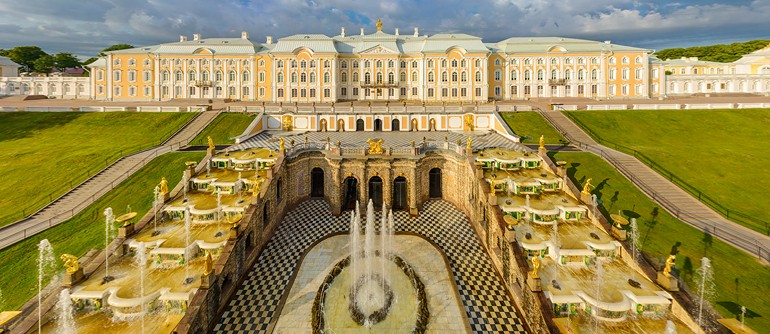
Nowadays Peterhof is a world-famous complex consisting of various palaces and gardens, and it's considered to be one of the most important sights in St. Petersburg and Russia. Before the 18th century its territory was occupied by only a few Finnish villages. It wasn't until year 1705 that the word "Peterhof" appeared in the first travel journal of Peter the Great (Peterhof is Dutch for "Peter's yard"). The tsar saw this area as a good place to construct a landing for travelling to and from Kotlin island. 
By 1714 Peter the Great had the idea to build a luxurious country residence, as luxurious as French Versailles. The complex of magnificent buildings was meant to glorify the power of Russia, and its recent victory over Sweden for an outlet to the Baltic Sea.
To turn this idea into reality the construction was started in the nearby village of Strelna, but later it turned out that the terrain in Peterhof would allow to build higher fountains due to its numerous underground springs, so construction was moved there. The best architects of Europe were invited to participate in the construction process. However, old drawings made by the tsar, his decrees, and notes on the documents suggest that the general concept design of entire complex, and, sometimes, design of individual architectural elements and fountains belonged to Peter the Great himself. The grand opening of the residence took place in 1723: by that time they planned out the Lower Gardens, dug the Sea Channel and launched some fountains; they also placed statues, vases, and busts on cascades, terraces, and alleys. Even then the beauty of "Peter's yard" astonished visitors, but a new round of construction started by the Empress Anna Ivanovna, successor of Peter the Great, that made Peterhof one of the largest palace-park ensembles in the world.
Above the Grand Cascade
Modern Peterhof includes several palaces and park complexes that were under construction for almost two centuries. The Lower Gardens, Upper Gardens, and English Park were built in the 18th century; the Alexandria Park, Kolonistsky Park, Meadow Park, Alexander Park, Sergievka Park, and Lower Dacha were built in the 19th century. Peterhof is often compared to Versailles (the tsar's project was realized as intended), but many critics believe that it's a wrong comparison. European palaces and parks are more continental, whereas Peterhof was born from the romance of sea and it perfectly blends into surrounding picturesque waters.
One of the most famous landmarks of Peterhof is Samson Fountain, the central fountain with 21 meter high water jets. According to the original plan, there was supposed to be a statue of Hercules defeating the Hydra of Lerna in the center of the Grand Cascade fountains, but it was replaced by a statue of Samson tearing the lion's mouth.
The Grand Peterhof Palace and the Grand Cascade
A fountain monument was erected in 1735 to commemorate the 25th anniversary of the historic victory of the Russian army over the Swedes at the Battle of Poltava on June 27th, 1709 (the day of St. Sampson the Hospitable). It explains why Hercules was replaced by Samson: the lion is associated with Sweden, because it's depicted on the arms of Sweden.
The fountain was badly damaged during the World War II, and the original statue was lost. The Samson that we can see now in Peterhof is a copy that was carefully re-designed using archival drawings and photographs.
Upper Gardens
There were other Peterhof sights that were damaged during the war: the Upper Gardens, the Lower Gardens and fountain water pipeline system. The restoration work started in 1944 continues to this day. But it's hard to notice: the complex of palaces and gardens has been restored almost completely, which you can see for yourself through our panoramas

27 Oct 2013

Tourism boosts in E China's Zhoucun during

Tourism boosts in E China's Zhoucun during 
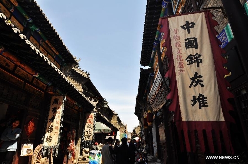
People visit a scenic resort in the Zhoucun District of Zibo City in east China's Shandong Province, April 30, 2013. Tourism boosted in Zhoucun during the three-day public holiday celebrating the upcoming international workers' day on May 1. The scenic resort in Zhoucun opened to the public free of charge since March 2011. (Xinhua/Dong Naide)

A visitor walks past posters promoting sesame cakes in the Zhoucun District of Zibo City in east China's Shandong Province, April 30, 2013. Tourism boosted in Zhoucun during the three-day public holiday celebrating the upcoming international workers' day on May 1. The scenic resort in Zhoucun opened to the public free of charge since March 2011. (Xinhua/Dong Naide)

People visit a scenic resort in the Zhoucun District of Zibo City in east China's Shandong Province, April 30, 2013. Tourism boosted in Zhoucun during the three-day public holiday celebrating the upcoming international workers' day on May 1. The scenic resort in Zhoucun opened to the public free of charge since March 2011. (Xinhua/Dong Naide)

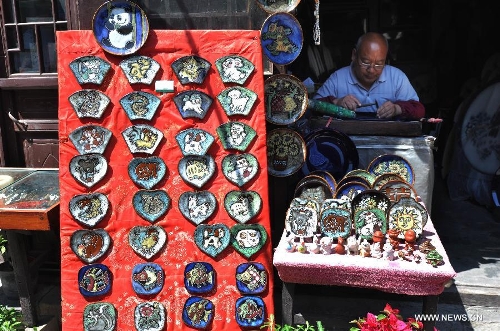
A craftsman engraves patterns onto porcelain pieces in the Zhoucun District of Zibo City in east China's Shandong Province, April 30, 2013. Tourism boosted in Zhoucun during the three-day public holiday celebrating the upcoming international workers' day on May 1. The scenic resort in Zhoucun opened to the public free of charge since March 2011. (Xinhua/Dong Naide)


tourism and best panorama in china natural


tourism and best panorama in china natural


السياحة واحلى المناظر فى الصين 2013 ، Tourism in China 2014


السياحة واحلى المناظر فى الصين 2013 ، Tourism in China 2014


السياحة واحلى المناظر فى الصين 2013 ، Tourism in China 2014


السياحة واحلى المناظر فى الصين 2013 ، Tourism in China 2014


السياحة واحلى المناظر فى الصين 2013 ، Tourism in China 2014 


paradise door


السياحه الصين 2013

8 Sept 2013

Tourism Conference 2013

Leaders to discuss emerging trends during World Tourism Conference 2013

Global leaders who will converge in Malaysia in October for the World Tourism Conference 2013 will discuss and address current and relevant issues related to the tourism industry.
The three-day conference, which is set to be organised by the Malaysia Ministry of Tourism and Culture together with the United Nations World Tourism Organisation and the state government of Melaka, will bring together stakeholders from UNWTO’s member states to discuss emerging issues in the tourism sector.
Tourism in Langkawi,Malaysia. [photo/asia-trip.info]
Tourism in Langkawi, Malaysia. [photo/asia-trip.info]
The conference is expected to bring together world leaders in tourism, high-level policymakers, specialists and experts from both the public and private sector to share experiences, while providing guidance for tourism development under this year’s theme Global Tourism: Game Changer and Pace Setters.
Tourism stakeholders set to discuss emerging issues in the sector in October. [photo/pravasitoday.com]
“Therefore, WTO 2013 should be attended by all travel and trade members in Malaysia, such as hoteliers, tourism officers, airlines and airport representatives, as well as tour operators among others, as they will get the opportunity to connect, share and learn during the event,” read a statement from the Malaysia tourism Ministry.
The ministry further confirmed that the conference will be held at the Equatorial Hotel, Melaka, from October 21.
SleepOut.com is East Africa's leading accommodation marketplace connecting travellers with hosts and their empty beds. Find thousands of unique accommodation options from beach huts to luxury holiday homes and all-inclusive resorts.

6 Sept 2013

Inside the Thrihnukagigur volcano, Iceland

Inside the Thrihnukagigur volcano, Iceland 

This panorama can be opened in several different resolutions. High resolution panorama with the best quality is about 7 Mb large and it is suitable for fast internet connections and modern computers. For slower internet and old weak computers we created the smaller low resolution panorama. Some small details have been  sacrificed but the size of low resolution panorama is nomore than 2 Mb.

Iceland is one of the most active volcanic regions in the world, with eruptions occurring every 3-4 years on average. It´s mostly due to its location on the Mid-Atlantic Ridge, where the Eurasian and North American plates are moving apart - and therefore literally opening the earth's crust. In the center of this ridge sits Thrihnukagigur volcano.
Thrihnukagigur volcano is dormant - it last erupted over 4,000 years ago. There are no indications of it erupting again in the near future. The volcano's name is directly translated as ‘Three Peaks Crater'.  The beauty of the crater mostly consists in the various colourations found inside it and its enormous - and to some extent intimidating - size. To put it in context, the ground space is equivalent to almost three full-sized basketball courts planted next to each other and the height is such that it would easily fit full sized Statue of Liberty into the chamber.
Photo from the top of the volcano
The magma chamber is often referred to as the heart of a volcano. It's there that the liquid rock waits to find a way through to the surface, causing a volcanic eruption. In most cases, the crater is usually closed after the eruption by cold, hard lava. Thrihnukagigur volcano is a rare exception to this, because the magma in the chamber seems to have disappeared. It's believed that the magma solidified in the walls or quite simply retreated to the depths of the earth.
Inside the Volcano
An open elevator system carries you down to magma chamber. It's speed is very slow to provide the opportunity to enjoy the amazing scenery. Elevator stops at 120m depth, where we were shooting our panoramas.
We want to thank Inside the Volcano company for organization of this tour.

29 Aug 2013

The Great Barrier Reef, Australia

The Great Barrier Reef, Australia 

Strange as it may seem, I will start the story about my trip to Australia from Ethiopia.
Some believe that spending winter in Moscow is not the best idea, and so some people tend to escape winter's embrace to beaches with palms trees.  Photographers feel cold as well and also dream of sunny destinations. So a trip to Ethiopia in early January looked like a good alternative to a standard downhill skiing.
Upon arrival to Addis Ababa the weather was great: +10 degrees Celsius outside the airport. Then we had to take another flight and to spend 8 hours in the car. Finally we were in the salt desert. It was suspiciously hot, obviously over 30 degrees Celsius, if not over 40.  So I was waiting for the sunset. The sun finally set but the heat did not subside. The sweat was dripping down my face and I started wondering - What is this place? And they explained that it's "depression" - 140 meters below sea level. It was cool that time of the year, but in the summer temperature goes over 50 Celsius. There was an occasional breeze, but dust would accompany it. I was trying to cool down in our air-conditioned jeep.
But instead of cooling the A/C brought me nothing, but a cloud of dust. I was almost boiling under the sun.  It turned out we had to spend 4 days there. I was saved by two things:  dipping my T-shirt and a sunhat in water every hour, which gave me 20 minutes of coolness, and a bottle of cold Coca-Cola from a local grocery store. It was the most delicious drink I have ever tasted in my life!
So how did I end up in Australia? Finally, after arriving at a decent hotel with internet connection, I read the news and saw a headline: "Heat waves in Australia". The story was about +46 degrees in Sydney and +52 degrees in Melbourne. By that time I already got my tickets to the Great Barrier Reef (hereinafter GBR) - to the part of the fifth continent closest to the Equator.  
Great Barrier Reef
That's when I realized what kind of winter I'm facing. This is why I thoroughly enjoyed Moscow cold weather during a weeklong break between Ethiopia and Australia.
This was summer time in Australia. Arriving at Cairns, I found out that even though my hotel faced the ocean, or rather the Coral Sea, the beach was empty. It turned out that summer is the dead season. The sea is so warm that the coastal water is filled with some harmful jellyfish and swimming is strictly prohibited.  


The heat of +38 degrees with 100% humidity was almost unbearable. But car and room air conditioning, as opposed to Ethiopia, worked just fine.  Taking my chances I've decided to go for a walk along the promenade towards restaurants. Of course I was sweating, but I didn't feel like I was suffocating while being locked up in a "submarine". Walking into any store brought a breath of fresh air. Plus Ethiopian hardiness somehow affected my body and it endured. I'll be getting ahead of myself by telling you that I froze near the open door while in a helicopter on the altitude of 1.5 kilometers.  

Great Barrier Reef
I love to plan my trips ahead of time. Two weeks before going to Australia I sent letters to many helicopter companies that offered flights over the BBR. And the only thing I heard back from them was silence.  I was expecting a prompt reply and I was very surprised when I didn't receive one. I decided that I will have to deal with it upon arrival. And just the day before my departure I finally received the first answer. The letter contained an apology and a link to the article. It appears that while there was a heat wave in the south, the north part of Australia was hit by days-long rainfall that flushed service provider's cell towers, and they sat on the bank without cell phones and Internet. This is why they received my email much later. But the important thing was that they did get it!
 The town of Cairns is considered a "gateway" to the BBR.  Coral islands in this area are situated close to the coast, and renowned diving points are only several hours away by a boat.  Apparently there is no jellyfish far away in the sea. 
But my task was to describe the beauty of BBR from above while in a helicopter.
Great Barrier Reef, Whitsunday beach
The first flight was a disappointment. During the flight, despite all enthusiastic descriptions, I didn't discover anything even remotely interesting. The only thing I saw was a sandy island measuring 5x15 meters.  It was a perfect place where you could feel like on a deserted island. However, the sight of helicopter standing still on the sand destroyed my exotic fantasy.  


When we returned, the head of helicopter company invited me to his office and started talking about getting residence permit in Australia.  I couldn't understand what was it exactly that he wanted from me. In the end he asked me directly if any of my friends wanted to get a residence permit by investing in the Australian economy, that is by buying his company. I promised to ask around.  But so far no one has responded!

After reviewing the photos I realized that I do not feel any joy and satisfaction.  And then I heard an email alert from my MacBook: a letter came from the company http://www.skysafari.com.au, located 80 kilometers to the north of Port Douglas.   They finally restored their connection to the Internet! I immediately dialed the phone number, and the voice on the other end assured me that I can reach much more beautiful BBR reefs from Douglas, and I can also see Lizard Island as a bonus!
In the morning I was standing near small trailer in the open field with parked helicopter.  This time we had a longer flight, but the pictures below us were more interesting: winding coral reefs lined up in chains, and Lizard Island, where we had to refuel, made a really big impression.  
Great Barrier Reef, Heart Reef
The sun was setting and we were on our way back when pilot suddenly steered towards the mountains, hovered over the waterfall and flew in the direction of a big cloud. When I asked him about it, he said that he wanted to show me a rainbow, which is formed around the helicopter shadow projected on the cloud. 


There was a rainbow, but so weak that it could not be captured: my camera refused to focus on a cloud, and the moment was lost. After we landed, I went through the photos and was about to admit that I had to wrap up the BBR project when I noticed a beautiful photo on one of the trailer's walls: it was a picture of a small coral island shaped like a heart.  When I asked if it was photoshoped, I was told that there is an actual reef like that 400 kilometers to the south of the shore and that it will take an hour to get there. I felt that my tour was incomplete without the "heart", and the next day I went to the town of Airlie Beach. 

Staying at the beachfront hotel, I finally figured out how Australians cheat jellyfish: a fabulous pool was dug 10 meters away from the beach, where you can safely swim in the sea waters.  The city was occupied by young people. As opposed to Cairns and Port Douglas there were at least five nightclubs open all night long, and small groups of girls in high heels strolled the main street from on club to another. They were accompanied by groups of boys, of course.
The next morning I flew to the Heart Reef. Along the way I saw several interesting islands, and one of them, Whitsunday Island, made a very strong impression.  It is a big deserted island and a National Park. After white sugar sand and bent palm trees I suddenly spotted a stunning Whitsunday beach - a very long beach recognized as the most beautiful beach in Australia.  The only way to get there is by boat or, like me, on a helicopter. 
Great Barrier Reef


Adjacent to the beach is a picturesque inlet that can be described as a river bed filled with water from the sea during the high tide that brings all sorts of shockfish and different sharks, and during the low tide it shrinks down and becomes sandy beach.  

I had to ask the pilot to slow down the helicopter in order to take pictures of this wonderful place. Another 40 minutes of flying and we arrived at the "heart".  Yes, this reef was worth the couple of days it took to get to it.  I was shotting it both from high and low altitude, using my telephoto lens until the pilot warned we were running out of fuel.   

On the way back we landed on the Whitsunday beach. I had a sunbed and a bottle of champagne with me.  I took my time sipping champagne from a glass while looking at the turquoise Coral Sea in the last rays of the setting sun. I wish I had someone by my side to share the delight of the "heart", sunset, and white sand.  

Heart Reef
It's amazing but at the moment I didn't feel heat at all, and I had absolutely no desire to return to my cold homeland.
Text and photography by Dmitriy Moiseenko


And now we would like to give you some interesting facts about the Great Barrier Reef.
The Great Barrier Reef is located in the eastern part of Australia and it is one of the greatest wonders of nature. It stretches 2,500 kilometers along the coast and has a territory of 344,400 square kilometers. It is the largest coral ecosystem of our planet and the largest natural object formed by living organisms.  


It's hard to believe, but during most of Australia's geological history its coastal waters have been so cold that corals couldn't exist there. It's explained by the fact that Australia has been a part of Antarctica for thousands of years. Australia drifted to tropical waters 65 million years ago. This event coincided with the rise of sea level, which created conditions that allowed coral reefs to grow near Australia's northeast coast. 

Great Barrier Reef


For the most part the Barrier reef is less than 400,000 years old because the rest of the time the sea level was too low for corals to grow. Its youngest parts were formed in the last 200 years, and the most rapid growth occurred in the last 8,000 years during the rise of the World Ocean level. 

The main part of the reef consists of more than 2,900 individual reefs of different sizes, ranging from 0.01 square kilometers to 100 square kilometers. The youngest reefs live on top of the old ones at an average depth of 15-20 meters. During low tide only a small part of the corals can be seen on the water surface, and in order to enjoy a more detailed picture you have to dive into the warm waters of the Pacific Ocean.

A shallow lagoon separates the coastline and the natural formation of 540 barriers consists of over 600 offshore islands that surround the reefs. It is a home to four hundred coral species of different colors: various shades of red, yellow, brown, purple, and even black. The Great Barrier Reef of Australia is a home to 1,500 species of ocean fish and 500 species of reef fish, including whale shark, the largest fish in the world. Waters around the reef are inhabited by several species of whales, dolphins and sea turtles, not to mention a great variety of shrimps, lobsters, and other small fauna. And finally, the reef provides shelter for more than 240 bird species. It is no wonder that this huge formation can be seen perfectly from the outer space.

Great Barrier Reef


Although Australia's aboriginal population started using the coral islands of the Great Barrier Reef about 40,000 years ago, for a very long time this natural monument has not been known to the Western civilization.  In year 1770 famous explorer James Cook survived a shipwreck near the Great Barrier Reef. Many other ships that came here later faced the same fate. The first person to sail around the Barrier Reef in year 1815 was Charles Jeffries. Only in year 1980 - when most of the archipelago was thoroughly explored and mapped - this route became safe to travel.

Each year near two million tourists visit the Great Barrier Reef of Australia. However, despite the government's efforts to establish a set of restrictions aimed to protect coral reef ecosystem, its destruction is inevitable. In addition to devastation caused by humans (for example, oil spills from passing ships, or even tourists' suntan lotions dissolved in the water), the Great Barrier Reef is also susceptible to risks created by nature itself.

Great Barrier Reef, Whitsunday beach
For example, the so-called fading occurs, which leads to large quantities of fast deaths of corals. It's caused by global warming that affects water temperature not only in Australia, but also around the world. The fragile balance of coral reefs is also greatly disrupted by tropical storms. And perhaps the worst enemy of the coral reefs is the crown-of-thorns starfish (Acanthaster planci) that sometime reaches up to a half-meter in size. They feed on coral polyps. In the 80s the echinoderms predators caused the most damage to the Great Barrier Reef in Australia.
Planet Great Barrier Reef


According to the study published by the National Academy of Sciences of the United States in October 2012, since 1985 the Great Barrier Reef has lost over 50% of corals that form its structure! It is unfortunate that we were not able to shoot this panorama before, but even now the Great Barrier Reef, a UNESCO World Heritage Site, is one of the most impressive nature monuments not only in Australia, but also in the entire world. See it for yourself on our panoramas.

Shanghai, China

Shanghai, China

The first day in Shanghai.
From the first moment in Shanghai I had a feeling that I was surrounded by endless construction sites. The area where we were staying looked like an anthill; we were surrounded by a crowd of people, heavy traffic, and scooters that were all over the place, even on the sidewalks.
We went to sleep without any strength left. In the morning, while cursing at the damned alarm clock, we barely woke up at 4pm local time. The weather outside was foggy (we couldn't tell if it was due to smog or heavy clouds). It didn't change in the evening either, but we still had to go shooting. We crawled out to the street where the first communication problem was waiting for us: taxi drivers stationed near our hotel didn't understand where we needed to go or pretended not to understand. In the end we had to go by foot. Past three or four blocks we realized that we wouldn't make it to the embankment before sunset. Dima managed to catch a taxi, and we had a fast and cheap trip to our destination.
Shanghai, China
We chose a little square where we unpacked our equipment and launched the helicopter. Dima suggested a very busy place for the evening and night shooting - the area around big flowerbed near the television tower. It was a heavy traffic area (with very lively crossroad), not to mention the square was surrounded by an overpass with the crowd of local people and tourists. There were too many people. At that point we couldn't find a better place and had to launch our helicopter.
Shanghai, China
It was getting dark fast. The helicopter flew up into Shanghai evening sky, and Dima kept saying that television tower refused to fit into the frame. It was a very crucial moment, not only because we were launching the helicopter over our heads, but the altitude was higher than 200 meters. And, finally, Dima said that everything worked out. The flying altitude was 270 meters. For a night flight it was so awesome! 
It made me realize that Shanghai was a very difficult place for taking pictures with a radio-controlled helicopter. There were too many high-rise buildings. Some were higher than 400 meters. But locals were very friendly: they seemed to be interested in what we were doing and even took some pictures with us. We weren't bothered by police. We had everything to continue our work.
Shanghai, China
Shanghai. Day two.
Elated by our yesterday's success of high altitude flight, we decided to raise the bar and launch the helicopter in the middle of a small park that was surrounded by high-rise buildings; but a guard came up to us and ordered us with gestures to stop the launch.
Shanghai, China
At first we pretended not to understand him, then we showed him our photos and explained that all we wanted to do was to take some pictures, and then, suddenly, Dima noticed radio-controlled helicopters inside one of kiosks not far from our starting point. Dima went up to the kiosk window and pointed to the helicopters, implying that we were trying to fly the same thing that was sold there. I couldn't understand the logic of that one minute pantomime, but the guard seemed to understand him and started consulting someone on the radio transmitter. After finished his conversation, he shook his head, but with less confidence than when we first met. I smiled and made a waving motion so he would step away from our launching point. He decided not to resist and joined the rest of the observing crowd gathered around us.
Shanghai, China
Generally speaking, Chinese were very curious, just like little children. Wherever we decided to launch our helicopter, we were momentarily surrounded by a small crowd of people. But if we didn't ask them to move they would get in our way: they would push us aside or try to look into the monitor, standing right in front of us.
Nothing interesting happened that day. Except, maybe, when a guard (or policeman, one couldn't tell by their uniform) approached us on the embankment and forbid us to launch the helicopter. I played dumb and ignored his request. He consulted someone on the radio transmitter, and in the end allowed us to launch the helicopter. After we landed our helicopter and showed him some of the pictures, we parted as friends.
Shanghai, China
When we finished shooting on the embankment, we headed towards the park. I asked Dima, "Where are we running?"
"We won't make it in time! It's getting dark very fast!  I can hardly see anything!"
"Dima, would you mind taking off your sunglasses?!"
" :)))))))"
During our second night flight we beat a new high altitude record - 300 meters above the ground.
Shanghai, China
Our stay in Shanghai was coming to an end, but it seemed we were able to show the most interesting places in the center of the city, that convey the atmosphere of an ultra-modern metropolitan city.
And now a few facts about Shanghai:


Not many cities can boast as many records as Shanghai, China's largest city, the world's most densely-populated metropolis, and the largest seaport on the planet. 


Shanghai's lands have been inhabited from ancient times: people who lived here were engaged in agriculture, fishing and salt production. The land had been passed from one dynasty to another, until this fishing village, with its favorable location on the Yangtze River near the East China Sea, was given an official status in year 751.  

Shanghai, China


During the centuries of Shanghai's history, the city has seen both peacetime and war: it was invaded and bombed, and then, with new powers, it was restored again. But only in 1992 Shanghai entered a fast development phase, which allowed it to become the leading city in the country, and then in the whole world. And now it's one of the world's major financial centers, the core of China's political intrigues, and, at the same time, the cradle of modern Chinese cinema and theater.


Despite the fact that the city is full of ancient temples and cozy side streets with houses built in the beginning of the last century, the first real symbol of Shanghai is the urban landscape. Modern buildings have a unique architecture, and the shape of their upper floors resemble flying saucers. One of the most amusing creations is a pedestrian ring-bridge built in Pudong district in 2012. You can go up as high as 6 meters above the ground by using stairs or escalators, and the pedestrian part of the bridge is so wide that you can line up 15 people in a row. In the evening the bridge has a very beautiful illumination.

Shanghai, China
Another most important Shanghai landmark is the Bund, a waterfront area on a plot of 1.5 kilometers with 52 buildings of different styles, from Gothic to Art Deco. Because of that it's often called "the museum of world architecture." Since 2003 it also houses Aurora Plaza, a beautiful 185-meter tower on the other side of the river. At night it turns into a huge screen broadcasting various videos that can be seen from the promenade: from commercials to news reports. 


There are more than 80 buildings higher than 170 meters in Shanghai. The most famous skyscraper, which ends up in any album of Shanghai photos, is a 492-meter high World Financial Center. It is crowned with a strange trapezium-shaped window intended to reduce air resistance. Initially, the window was round, but some people thought it was associated with the sun on the flag of Japan. As a result, the circle turned into trapezium, and building started to look like a giant beer bottle opener. Nowadays it's the highest building in the city, although it's threatened to be overshadowed by another 632-meter high skyscraper that is being built in the Pudong district with a predictable name Shanghai. 

Shanghai, China